STAY CONNECTED: Have the stories that matter most delivered every night to your email inbox. Subscribe to our daily local news wrap.

Fiona hits Newfoundland: Houses collapse, resident rescued after she is swept to sea

Sep 24, 2022 | 1:54 PM

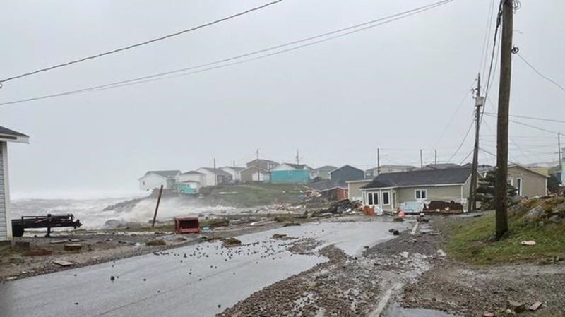
CHANNEL-PORT AUX BASQUES, N.L. — Neighbours pulled a woman from the waters off southwestern Newfoundland early Saturday after a storm surge caused by post-tropical storm Fiona enveloped her home, causing it and several others to collapse into huge waves driven by hurricane-force winds.

RCMP Cpl. Jolene Garland said police were also investigating reports that a second woman had been swept into the Gulf of St. Lawrence under similar circumstances, but the Mountie said the status of that woman had yet to be confirmed.

Garland said the first woman, who she did not name, was given medical treatment and is believed to be fine. As for the second woman, police have yet to confirm reports that the rising waters pulled her from her basement in Port aux Basques, N.L.

“It’s too dangerous for us to enter into a search for that woman at this point,” Garland said in an interview. “We can’t substantiate her current location.”

Meanwhile, Garland confirmed that other homes in the coastal community were evacuated as Fiona closed in on Newfoundland’s west coast.

Both incidents were reported between 9 a.m. and 10 a.m. local time, when a storm surge raised water levels at Port aux Basques to a record level. At the time, two peak gusts were recorded at 133 kilometres per hour, according to the weather office in Gander, N.L.

“We’re all used to wind and rain here, but this is not a normal amount of wind and rain,” Garland said. “The ocean waves that surged onto residential properties is abnormal. It has caused a lot of electrical fires … and many are without power as a result. And there’s a lot of flooding.”

Earlier in the day, the town of 4,200 declared a state of emergency.

Rene Roy, editor of the weekly newspaper in Port aux Basques, said he saw evidence that nine homes, including a two-storey apartment building, had been washed out to sea as wind-driven waves hit the rocky shoreline and soared about 25 metres into the air.

“Lower Water Street is devastated with damage,” said Roy, who is also sales director at Wreckhouse Press Inc., which is named after an area in southwestern Newfoundland where howling winds are common. “There are homes gone. There are homes in the street.” 

Roy said the small island at the head of the town’s harbour, which includes the Channel-Head lighthouse, usually protects Water Street East from the Gulf of St. Lawrence. But that didn’t happen early Saturday as the waves broke over the island. 

“The water was smashing in, 80, 90 feet high,” he said. “It just took that apartment building.” 

He said it was unclear what happened to the building, but recalled it backed on a 10-metre-wide lawn that once stood about two metres above the water in the town’s bay. It had about a dozen units, he said. 

From his cousin’s home on Mouse Island, Roy said he could see three houses “now a pile of rubble in the ocean.” 

Powerful gusts are common in Port aux Basques, which is at the island’s southwestern tip and is home to a busy port that includes daily visits from ferries that link Nova Scotia with Newfoundland. 

The homes in the low-slung, coastal community are built to withstand the worst that the ocean has to offer, Roy said, adding he once used a device known as an anemometer to measure gusts reaching 130 kilometres per hour on his street. 

Born in Port aux Basques, Roy moved away but returned home seven years ago. The former firefighter said a 52-year-old neighbour who has lived in the community his entire life confirmed that he had never before witnessed such a powerful storm. 

“It’s one for the ages,” Roy said.

David Neil, a meteorologist at the Gander weather office, said Fiona’s extraordinarily low barometric pressure — which set a Canadian record when the storm made landfall in Nova Scotia between 3 a.m. and 4 a.m. — would have been responsible for raising water levels at Port aux Basques to a record 2.73 metres at 10 a.m.

The low pressure at the centre of the storm acts like a suction cup, lifting the water well above its normal level. When coupled with the high tide, the result can be disastrous. It’s called the “inverse barometer” effect.

As well, Neil said the waves were reaching 12 metres high close to shore.

“This storm was extreme, even for that area,” he said. “It was a perfect combination to hit that area hard.”

— By Michael MacDonald in Halifax.

This report by The Canadian Press was first published Sept. 24, 2022. 

The Canadian Press