STAY CONNECTED: Have the stories that matter most delivered every night to your email inbox. Subscribe to our daily local news wrap.

New Brunswick shuts Trans-Canada Highway as flooding hits record levels

May 3, 2018 | 4:30 PM

FREDERICTON — New Brunswick shuttered a large section of the Trans-Canada Highway Thursday night, and warned motorists to be on watch for wildlife seeking refuge, as floodwaters rose to record levels along the Saint John River.

Barricades went up on the four-lane highway between Moncton and Fredericton at 7 p.m. local time Thursday, even as forecasts threatened more rain.

Transportation and Infrastructure Minister Bill Fraser said in all 81 roads and bridges have been closed to traffic, while dozens of other roadways and ramps are partially closed in the flood-weary province.

“We are seeing weather events like we have never seen before,” Premier Brian Gallant told a briefing Thursday afternoon.

“This is most likely going to end up being the largest, most impactful flood that we have ever recorded here in New Brunswick, so it certainly puts … all of our resources and people to the test.”

Geoffrey Downey of the Emergency Measures Organization said the river has hit 5.34 metres above sea level in Saint John — water levels not seen since 1973 — and will likely exceed that on Saturday when forecasts say it could reach 5.8 metres.

Downey said the rising Saint John River is causing more people to evacuate in areas stretching from Fredericton south to Saint John, where the situation is expected to worsen in the coming days.

“The problem is we’re venturing into uncharted territory,” he said. “Who knows how far it’s going to go up, so how many homes is it now going to reach?”

He said roughly 100 homes have been evacuated, affecting about 260 people, but that those numbers are expected to climb.

“It is clear that due to flooding there will be houses and families that are isolated,” Gallant said in Fredericton.

“We are therefore taking steps to increase our capacity and capability for marine operations. We have requested assistance from the Canadian Coast Guard and the federal government has granted our request.”

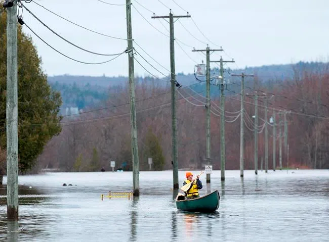
North of Saint John Thursday evening, people lined up in the rain where the only road to Darlings Island disappeared into the flood waters of the Kennebecasis River.

While many residents used their own canoes and kayaks to reach the island, others were waiting for a local volunteer dubbed “Uber Rob.”

Since Monday, Rob Dekany has ferried people to the island with his own boat.

Resident Colleen McDevitt says in past floods, the province provided a shuttle service — but not this year.

“It’s very stressful and maddening that we have to figure it out on our own,” she said. “We feel stressed and almost left to fend for ourselves.”

The EMO in Saint John is recommending that anyone in low lying areas along the Saint John River “evacuate their homes immediately with their pets and seek accommodation with family or friends,” the municipality said in a statement. That includes Randolph and the Westfield Road area along with Ragged Point and Beach roads.

“We encourage people to get out in daylight, get out while there is still some dry land around them,” Fraser said.

“We recognize that flooding is an annual event for many in New Brunswick who live and work along the Saint John River. They may be used to it and they may not feel any sense of urgency to evacuate but this year is very different.”

Officials said Thursday afternoon water levels in the Fredericton area — where parts of downtown have been under water for days — have remained relatively stable from 8.12 metres on Tuesday to 7.92 metres early Wednesday.

Outside the city, water levels had risen slightly in several communities including Maugerville, Jemseg and Grand Lake.

In the Saint John and Quispamsis areas, water levels had risen from 5.11 to 5.34 metres. EMO said it expected the flooding to continue over the next five days.

Oromocto fire Chief Jody Price said boats are being used to rescue people from homes across the river in Maugerville, and the longer people wait to leave, the harder it is to get to them.

“The higher the water gets — and it has been a continual rise — it is more difficult for us. We went from Friday, when we could get people out of there with vehicles, to today, where we can’t go over there without a boat,” Price said. 

Officials said the NB Southern Railroad would provide a free one-way shuttle evacuation service to residents along the Westfield Road area in Saint John, which consists of 599 houses and over 1,400 residents.

The province has shut down its river ferries with the exception of the Gondola Point ferry, which continues to cross the Kennebecasis River.

The Trans-Canada Highway detour, affecting both eastbound and westbound lanes between Moncton and Fredericton, is “in excess of a couple hundred kilometres” in part because of the widespread road closures surrounding the highway, Fraser said.

He cautioned motorists not to cross barricades, noting that even if water has receded roads must be inspected before being reopened. He said roads could be “compromised” and cave in or collapse under the weight of a vehicle.

Fraser said a significant number of moose and deer have been spotted on roadways as wildlife are flooded out of low-lying wooded areas. He warned motorists to use caution on the roads, especially in areas where wildlife sightings are common.

Transportation Department spokesman Jeremy Trevors said that roads further north in Miramichi and Bathurst had also been closed by flooding.

Downey said the EMO was busy fielding calls from people looking for sandbags and help evacuating.

“People are asking for all kinds of sand and sandbags — that’s a huge one right now,” he said. “We’re still doing evacuations and we’re encouraging anyone who self-evacuates and doesn’t need help that they register with the Red Cross as well.”

– With files from Alison Auld, Keith Doucette and Brett Bundale in Halifax

Kevin Bissett, The Canadian Press