STAY CONNECTED: Have the stories that matter most delivered every night to your email inbox. Subscribe to our daily local news wrap.
Photo: City of Grande Prairie
Traffic Planner

City unveils new interactive Traffic Planner Map

May 17, 2019 | 12:03 PM

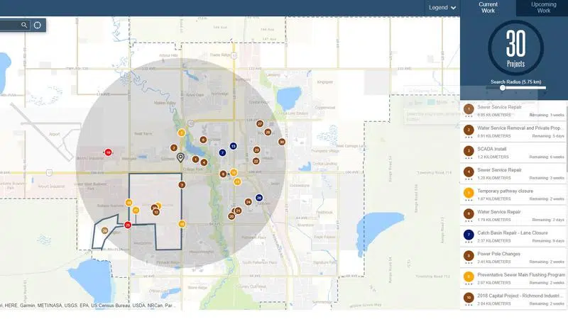
The City of Grande Prairie has unveiled a new interactive Traffic Planner Map on its website that highlights construction projects going on around the city and how you can best plan your commute during construction season.

The new planner is an upgrade on the city’s old GIS mapping tool, known as Construction Manager, and goes into further detail about each project and its affect on traffic in real time.

“Overall, it’s a re-tool of an existing application, but it’s been brought into more of a modern stream… then it was previously.” said Kent Bowman, GIS Manager with the City.

The biggest upgrade is that the map now has the ability to show traffic patterns in real-time, both construction related and due to heavy congestion. The site uses both historic traffic patterns, in tune with real-time traffic on all city roads, provided by a third-party data provider, that shows where traffic has slowed down. Traffic flow is indicated through different colours along the road network.

Bowman also notes that this map is for more than just on-road traffic.

“The idea behind it is traffic of any kind, which could include pedestrian traffic. So, foot traffic, bike traffic.” said Bowman “If there is work being done on say, a trail or a path. It’s not just necessarily tied to traffic patterns themselves. It could be exposed to other areas.”

The map shows each construction project, both current and upcoming, that are completed by the city. It also shows private-industry construction that happens on public lands that require a city permit. Users can scroll between a five and 20-kilometre radius that will show each numbered project in that area. By clicking on a specific project, it will show the timeframe, the scope of the project, traffic impact, transit route disruptions, the project owner and in some cases, the contractor that is on site.

The map is also mobile enabled and can track your current location through your phone.

“I think it is a much-needed upgrade and it should improve the information provided, as far as the construction season is concerned,” adds Bowman.

You can check out the new map on the city’s website.